Photogrammetry
Understanding Construction Photogrammetry
Photogrammetry is the technological discipline of capturing a 3-dimensional model of reality using photographic images, which in construction is often augmented with a building information model (BIM) or geographic information system (GIS). Apart from light-based photography, photogrammetry in construction can also harness light detection and ranging (LiDAR), white-light digitizers and other technologies that generate a point cloud—a file containing x, y, z coordinates for discrete points in space. Photogrammetry can also involve creation of digital terrain models based on multiple aerial or satellite images.
Cameras or sensors used in photogrammetry can be fixed on a tripod, worn on a garment on-site, flown through the air on a drone or even affixed to a crane for an aerial view of the site.
Some contractors may access libraries of commercial photogrammetry data for take-offs, site planning or landscaping—at least when the site exists in one of these libraries. A contractor may also commission drone data capture or other measurements for take-offs or other purposes, but as photogrammetry makes its way into the day-to-day management of the project, contractors can or with some technologies even must capture data themselves.


Cintoo


Constru


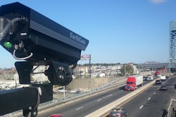
EarthCam

EcamSecure

Eng

Evercam


Flir

Understanding Construction Photogrammetry
Photogrammetry is the technological discipline of capturing a 3-dimensional model of reality using photographic images, which in construction is often augmented with a building information model (BIM) or geographic information system (GIS). Apart from light-based photography, photogrammetry in construction can also harness light detection and ranging (LiDAR), white-light digitizers and other technologies that generate a point cloud—a file containing x, y, z coordinates for discrete points in space. Photogrammetry can also involve creation of digital terrain models based on multiple aerial or satellite images.
Cameras or sensors used in photogrammetry can be fixed on a tripod, worn on a garment on-site, flown through the air on a drone or even affixed to a crane for an aerial view of the site.
Some contractors may access libraries of commercial photogrammetry data for take-offs, site planning or landscaping—at least when the site exists in one of these libraries. A contractor may also commission drone data capture or other measurements for take-offs or other purposes, but as photogrammetry makes its way into the day-to-day management of the project, contractors can or with some technologies even must capture data themselves.
Drone Photogrammetry
Many contractors involved in horizontal construction and construction materials companies already use drones to manage their work sites. For horizontal contractors, winged aircraft that are light and can cover a lot of territory usually make the most sense. When contractors want to capture tight up to a structure, inspecting a façade or collecting as-built data of mechanicals prior to concrete being poured, a multi-rotor craft with vertical takeoffs and hover capabilities is desirable.
Handheld And Worn-on-the-body Photogrammetry
Vendors of software used to merge photogrammetry images with BIM, a plan set or a GIS often recommend specific cameras for their software and method. Some will require a 360-degree camera. Others can capture from a DSLR or even a smart phone.
Fixed jobsite photogrammetry
A 360-degree camera, or multiple cameras, positioned strategically on a job site can create a detailed view of a horizontal construction project useful for security, site planning and schedule management.
Software for Construction Photogrammetry
Contractors can run software on local machines or in the cloud that processes the images into maps or 3D models. This may be a desktop application, which saves challenges associated with getting image and point cloud data to the cloud. Increasingly, processing is done by SaaS applications in the cloud—either by software associated with a piece of hardware like a drone or an aerial mapping application. Other vendors have combined systems of various light cameras, LIDAR scanners and other reality capture devices to offer contractors a complete system for multiple forms of reality capture.
What is happening in construction photogrammetry now is the convergence of several trends:
- Merging and consolidation of multiple types of data capture files and manners of collecting these files into applications that present it in context in a centralized view. LIDAR, 360 cameras, SLAM, video and more can all relate to the same model and provide a contractor a flexible approach to reality capture.
- Emergence of machine vision to turn images into data used in progress reporting, application for payment and to support change order requests. This technology is advancing rapidly, and machine learning is rapidly mastering recognition of project elements and can record how much conduit, cable, drywall, piping and other work has been complete, calculating and documenting value of work put in place.
- Software is packaging photogrammetry data and surfacing it in role-appropriate ways for multiple stakeholders and project collaborators. This drives photogrammetry data deeper into a contracting business and a project team, making the most of the investment and improving communication.
- Sensor data, geolocation data for people or equipment, equipment telematics and other data sets from non-photogrammetry-related applications are also being combined with images and point clouds in a single pane of glass for real time project management and visibility. This means that regardless of how data is collected, it can be viewed and potentially managed from within a single application.
- Automation of data capture through robotics. The Boston Dynamics-Trimble Spot collaboration is the archetypical version of robotic site photogrammetry as the robot can capture from the same site more consistently than a person without consuming labor hours.
- Transition of data processing software-as-a-service (SaaS) applications with some holdouts to desktop software. Desktop software may require more image processing and software skill than cloud applications. Cloud applications also may loop in a human review step to manage exceptions and correct errors.
- Takeoffs and estimating for horizontal construction projects
- Evaluating site access options for equipment during construction
- As-builts, progress reporting and dispute resolution during work-in-progress
- Risk reduction and safety monitoring
- Capturing the as-is state of a built structure or mechanicals prior to remodeling or refit
- Support for project communications with stakeholders