As drones become a more central tool for construction site data capture and photogrammetry and software vendors roll out machine learning for analytics, the industry is seeing a convergence of drone and other data sources to provide a more unified, actionable vision of the physical environment.
For horizontal contractors, a drone can be a rapid way to capture a site at various stages in the project lifecycle:
Drone photogrammetry can automate takeoffs for sitework projects
Aerial views can help contractors plan where to best access and marshal equipment on a site
During work-in-progress, drones can document work performed and machine vision applications can break this image data into structured data that will underpin application for payment and dispute resolution
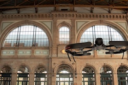
In vertical construction, drones with vertical takeoff and hover capabilities can capture façade work or even navigate close into vertical work, risers and mechanicals to document as-builts prior to enclosure of walls.
Over the lifecycle of the asset, drones can also capture data to support maintenance and asset lifecycle management processes for buildings, infrastructure and even linear assets like pipelines and roadways.
Drones have their place in helping contractors with reality capture. Apart from drone hardware though, contractors also need technology to process those images into datasets that become part of their overall construction workflows. Contractors can subscribe to robust software-as-a-service (SaaS) applications that automate much of the work involved in processing image files so they can be married with project files like plans, a building information model (BIM) or a geographical information system (GIS). Some of these applications also include tools for machine vision-based progress tracking and project communication with stakeholders. Other contractors still rely on desktop-based software to process construction drone imagery, in part due to the challenges of uploading large files to the internet. Some sophisticated users also may relish the control that processing on a local machine can give them, and leveraging skills they have acquired over years of training and experience. Even with the most advanced drone photogrammetry technology available today, some human expertise is still important. Even cloud-based SaaS drone photogrammetry software often loops human surveying and data professionals who review and troubleshoot image processing.
Not just for drones anymore
What is happening now before our eyes is the consolidation of software used to manage drone flights for data capture and photogrammetry broadening out to also encompass other photogrammetry and even point clouds from other sources. After all, this data does not exist in a vacuum—contractors may also have access to photogrammetry from other capture methods too. In some cases, like PropellerAero’s addition of its DirtMate data collection tool for terrestrial equipment, this can take place through organic development. In other cases, we are seeing and will continue to see technology vendors relying on partnerships or engaging in mergers and acquisitions to lash together a complete solution.
READ OUR PROPELLER AERO IRONPROS DEEP DIVE
In a single week in October of 2022, the market was hit with a succession of announcements illustrating this trend. Photogrammetry vendor Avvir announced a partnership and integration with drone management and image processing vendor DroneDeploy. Then, Avvir announced its acquisition by digital reality solutions vendor Hexagon AB.
Then, DroneDeploy announced the acquisition of Avvir competitor StructionSite.
“Companies across industries have been asking for a unified view of their sites: a single platform to document, inspect and measure the exterior and interior of their assets and infrastructure,” DroneDeploy CEO and Co-founder Mike Winn said. “We're excited to deliver on this, combining DroneDeploy’s leadership in aerial reality capture with StructionSite's leadership in ground reality capture to enable full reality capture for 40% of the top 400 general contractors.”
“I am thrilled that with the DroneDeploy and StructionSite teams joining forces, our combined technology, resources and expertise will deliver the unified experience our construction customers and the wider industry have been asking for,” Structionsite CEO and Co-founder Matt Dalysaid. “Together, we can accelerate StructionSite’s product roadmap through an integrated platform that will enable some of the world’s largest construction companies to deploy autonomous aerial and ground robots to deliver efficiency and cost savings at scale.”
Selected Construction Drone Systems Vendors
Construction contractors who have or are planning their drone data capture programs will want to learn as much as possible about the supporting software. The IronPros Drone Systems section is an excellent tool for this, and includes pofiles and listings for both horizontal, widely-used applications Some products like Propeller Aero are strictly focused on construction—other drone software systems will also serve industries like insurance, education, emergency services and disaster response. Other vendors like SiteAware provide services for drone photogrammetry directly as well as provide a technology platform, and others including JP Global Digital are evolving past offering services to focus more on a standardized product that includes drones for point cloud data capture and photogrammetry.
Contractors will also want to make sure the drones they specify or acquire are compatible with the software they choose. This is becoming more important as drones come to market with gimbals that enable the camera to move, either from side to side or simply in orientation between portrait and landscape. As these drone features become available, the software must be able to access them and adjust the flight pattern and data processing methodology accordingly.
Some drone manufacturers have their own native software applications, but software designed specifically for construction will extend the value of drone imagery further into the organization. Failing this, a survey manager or others associated with a construction project will spend a lot of time manually processing and distributing images, or parts of them, to different stakeholders. It may be difficult to package the images in different ways for different construction disciplines, and phases. The software will also often include tools to embed the imagery into project-related workflows and communications with the owner-designer-contractor-subcontractor project team. Machine vision applications are often embedded to automate measurements progress reporting and identify nonconformances.
DroneDeploy
IronPros is pursuing a post-acquisition briefing with DroneDeploy—so watch for deeper insights soon. Prior to the StructionSite acquisition, DroneDeploy already offered options for both ground-level walkthroughs and autonomous drone missions. The data can then be processed into elevations, plant studies and as thermal data, used to compare as-built to design and processed into 3D and 3D maps, photos or videos. Drone operations functionality includes tools for equipment management, track pilot credentials and secure LAANC authorization in controlled airspaces. DroneDeploy also can integrate with existing workflows in a contracting business by driving drone data into design, project management or document management processes. Users can also open DroneDeploy to their team from within the interface. The application can integrate with a broad spectrum of other software products including construction-specific solutions including Procore, Autodesk Construction Cloud, ArgGIS and PlanGrid. Users can even buy their drone insurance through an integration with SkyWatch Drone Insurance.
Propeller Aero
PropellerAero’s backbone product, PPK, automates drone image capture and processing. Users fly their site using a supported drone and AeroPoints smart ground control points to capture highly accurate, geotagged aerial images for drone mapping. Once captured, users can drag and drop flight data into Propeller PPK so it can be transformed into a 3D map of using Propeller Aero’s proprietary technology within 24 hours. This map has been reviewed by a team of GIS experts who confirm the accuracy and verify the results.
AeroPoints are their line of high-precision, smart ground control points that provide a frame of reference for drone photogrammetry. Contractors calibrate these AeroPoints with a permanent survey mark like a slate mark and by placing the AeroPoint at that location. Or, contractors can update the AeroPoint by importing a RINEX file or data from Trimble or Topcon calibration files.
The Propeller Platform is a drone survey visualization and analytics application that displays the project through a realistic and geographically accurate 3D model with an interactive timeline slider to go forward and backward in time. Crew is a Propeller Platform add-on that enables creation and sharing interactive maps with professionals in the field.
DirtMate is the company's survey-grade GPS receiver that does not fly on a drone but rather rests on earthmoving machines and produces elevations, measuring and capturing the elevation and using the ribbon to build a 3D model of the project with hourly and daily quantities.
Read the Propeller Aero IronPros Product Deep Dive
Pix4D
Mobile and drone mapping software company Pix4D meanwhile focuses more on processing the images from drones and from mobile devices than flight or drone program management. The company makes available a free drone planning app, Pix4D Capture, that integrates with drones from DJI and Parrot. The mobile app is available for iOS or Android, defines drone altitude and sets the camera angle, image overlap and flight speed. It then uploads images directly from the device to Pix4D software in the cloud for processing. The cloud application then enables contractors to integrate photogrammetry surveying in with current workflows.
A survey manager or virtual design and construction (VDC) professional can choose to add ground control points and checkpoints to asses accuracy of your results—visually verify and improve the accuracy of your project with PixrD’s rayCloud 3D environment that connects original images to each point of the 3D reconstruction, for virtual inspection from anywhere
Reduce surveying time and easily update maps, models and projects
But Pix4D also encompasses other reality capture and photogrammetry methods, including LiDAR. Unique tools in the Pix4D toolbox include:
A crane-mounted solution called CraneCamera, harnesses movement sensors and firmware to automate captures that can then be used for mapping, BIM comparison and as-builts.
The Pix4D Catch app, available for iOS and Android, turns mobile device like a smart phone or tablet into a 3D scanner for photogrammetry. With Pix4D Catch, a contractor can capture imagery and their current location, and generate an accurate 3D model of reality, scaled and georeferenced for 3D outputs. Users can then export files to Pix4DCloud and other Pix4D products.
A hardware tool for real-time kinematic positioning, the RTK Rover, which corrects problems with global navigation satellite systems (GNSS). The RTK rover can measure with a laser or photogrammetry, and can gather data even when there are obstructions like trees and vegetation. This tool comes into its own when documenting position of trenching and the utilities installed within or capturing volume of stockpiles.
Botlink
Botlink markets its Capture Flight app, Inisghts Mapping software and cellular drone hardware primarily to aggregate producers. But the company is moving towards an offering for construction, primarily to do volume capture for bids. But the overall vision is to enable higher-frequency data capture of the job site and distribute the data as required by construction management software and applications used across the project team.
For the time being, Botlink is focusing on offering aggregate producers a simple, walk-up-and-use drone application to help them manage their business. While drones have multiple use cases in aggregate mining, the strongest one may be measuring who took how much inventory for billing and dispute resolution. But just keeping track of inventory assets for accounting purposes drives significant value as an aggregate mining operation will need visibility into how much money they have laying on the ground and what their total production has been.
The ease of use of the Botlink solution mean it is a solution of choice for smaller aggregate operations that do not have a full time GPS professional, but it scales up to operations with 30-plus locations and 150 different products throughout those locations.
Because of the remote nature of many quarries, uploading drone photogrammetry data can be a challenge, with the common work-around being taking the SD card home or to a location with a high-speed internet connection. Botlink customers get a 14-day free trial phase during which they can define their processes and ensure the application is working for them.
The software is sold in tiers that are appropriate for different size operations and volume of drone flights and data processing.
Botlink supports DJI drones, but also offers hardware that can be installed on other drones for beyond-visual-line-of-sight (BVLOS) operation.