PART I: Is Now the Time for Augmented Reality in Construction--Trimble AR Connect
PART II: vGIS Extends AR Solution for Utilities
PART III: XYZ Coming to Market With Ultra-Accurate Construction AR
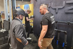
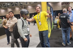
Toronto-based vGIS is not the incumbent and not a well-recognized construction technology giant, but Founder and CEO Alex Pestov said the company has some differentiators for its augmented reality solution and a new solution aimed specifically at utility and heavy construction that are helping them make rapid inroads in the market. The company employed 20 at the time of our September 2024 discovery call, and was getting word to market on vSite, its new offering.
The complement of employees is extended by a team of partners and resellers. The company does sell direct, but also relies on partner-led sales by independent dealers and through a global distribution agreement with Leica Geosystems, whose dealers are authorized to resell vGIS products. This includes the vGIS augmented reality solution as well as the new product, vSite.
“Our number one priority is the vSite construction coordination platform we unveiled at the Advancing Construction Technology Conference,” Pestov said. “It is highly specialized for infrastructure construction projects, including everything that happens outside like highways and utility relocations. And we feel that we bring a unique value proposition that combines augmented reality, paired with the three-dimensional digital twin, accessible 24/7 that can be used in a very unique way to complete common workflows such as RFI processes and review of designs. We are continuously enriching vSite’s capabilities for bringing in data that is relevant for the reduction of site visits and rework by making data available to the users who can benefit from it.”
Contractors looking for a straightforward construction AR or mixed reality solution can still look to vGIS, but vSite according to Pestov extends that solution to settings where AR and mixed reality solutions are often poorly suited. vSite also extends vGIS with a common data environment that can contain a broad spectrum of geospatial data.
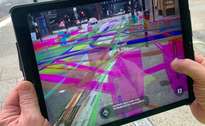
Apart from this common data environment, Pestov said vSite users will be able to reduce visits to the site, compare multiple design changes and select the optimal one and quickly identify utility locations. As work progresses, project stages can be captured with time stamps for an indelible record of work. The final project is archived, including multiple scans of each area to reveal what was done when and what is obscured underground.
“What we are designing is a geospatial hub that works hand-in-hand with vGIS, but it gives you the optimal tools for the job, depending on where you do your job, and depending on the type of job that you do,” Pestov said. “We combine AR with a GIS application where things can be located and married up with a model and our view of the project site. The solution can use any type of geospatial data a customer wants to include, be that from BlueBeam, GIS or point clouds produced by Drone Deploy or PIX4D. This gives users a complete geographic context to your data that you use on a construction site.”
vGIS for Construction AR
The original offering, vGIS, can still be bought as a standalone system, and will be a fit for contractors intent on using it either outdoors or indoors with the strongest applications being outdoors.
“We have centimeter-level accuracy outdoors—and that can theoretically be sub-centimeter,” Pestov said. “For that, we use a high-precision Leica GS18 which can get us to within 7 mm. But practical accuracy is complicated by things like tilting the device. We have a very unique feature—software-based tilt compensation—but there is a delay so accuracy can temporarily fall to between one and 4 or 5 centimeters. But accuracy does not degrade over time as you move for miles.”
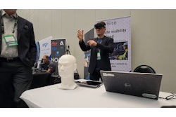
vGIS supports Microsoft Hololens and Hololens2, and delivers a mixed reality experience on both iOS and Android devices. Like Trimble SiteVision, vGIS can also open the mixed reality experience to remote users for collaboration.
“vGIS is a good tool for indoors, especially when extending it for mixed reality,” Pestov said, adding that the list of supported devices will be growing shortly, and that a patent pending calibration tool for QR Codes simplifies preparing a site for augmented reality. “If someone is replacing VisualLive, this is a good replacement.”
vGIS and vSite Pricing and Market
The vGIS construction AR solution can cost a contractor as little as $100 per month for a single user using a bring your own device (BYOD) approach, which Pestov said most customers do. There is no minimum number of users for vGIS.
vSite will typically sell for 10 users to thousands of users on a project, with pricing based on the size of the site, hinting that prospects with larger projects can press him for discounts during the market launch.
Pestov said the company is targeting key segments with vSite including:
- General primary contractors for infrastructure work and larger infrastructure consortiums
- Consulting engineering firms which can use the technology for designing models, explaining models to customers and updating the model in response to change orders and feedback
- Federal and state governments including departments of transportation
- Utilities for larger projects like utility relocation work, where they can get comprehensive view of the as-built immediately on completion
vGIS will also be a fit for vertical construction, according to Pestov.
“We are told vGIS is one of the best if not the best AR tool for vertical construction because of the workflows for positioning and the advanced positioning capabilities we have,” Pestov said. “But vSite is primarily for civil or horizontal construction.”